
20 Apr 2027Ends 14 May 2027
AvailableConfirmed departure
€6,397 double/twinSingle €7,352
BookAntananarivoAntananarivo
Follow the Tsiribihina downstream, cross the limestone passages of the Tsingy and walk in Kirindy’s dry forest before turning south along the coast. After time in Ambatomilo and Ifaty, the journey moves inland through Isalo’s sandstone canyons and Tsarasoa Valley’s granite country, then into Ranomafana rainforest.
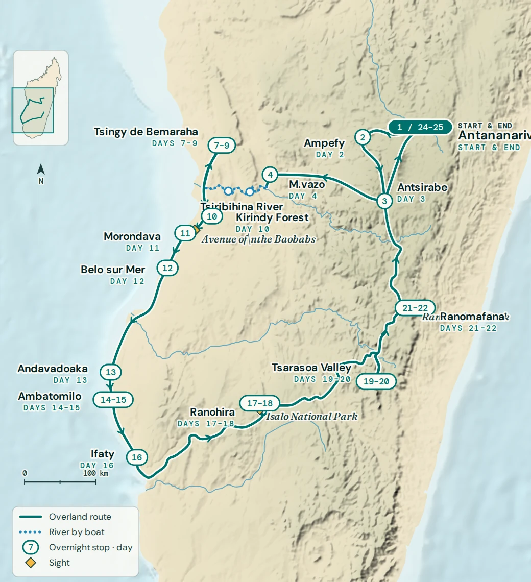
17 special mentions
Day by day
Road and river conditions affect the pace of travel, and some days involve long journeys on rough tracks. Wildlife sightings are never guaranteed. Your guide will explain the plans for each day and any necessary adjustments.
Tonga soa, welcome to Madagascar. Meet the WAU team at Antananarivo airport for the transfer to your hotel. There is time to settle in after your flight before the journey begins.
In the evening, come together for a welcome dinner, meet your fellow travellers and talk through the days ahead. It is a chance to ask practical questions and get to know the team before setting off.
Leave Antananarivo for the Itasy region, travelling about 120 km to Ampefy, roughly three hours of driving. Beyond the city, roadside fruit and flower stalls give way to cultivated hills and villages. Look out for brick making along the road and fields growing crops such as tomatoes and papaya.
Visit the Amparaky geysers near Analavory, where cool water rises from artesian wells rather than volcanic heat. The day also includes Lilly’s Waterfall, with time to walk around the viewpoint and photograph the falls and surrounding countryside before settling into your hotel in Ampefy.
The road to Antsirabe winds through cooler highland country, passing Faratsiho and continuing towards Sambaina, where it meets the RN7. Allow around three hours of driving for the 150 km journey. Mountain slopes and cultivated valleys make this a different view of Madagascar from the warmer west that lies ahead.
In Antsirabe, explore the city by colourful rickshaw, starting around the railway station. Visits to local workshops introduce the town’s crafts, from working with semiprecious stones to embroidery and miniature models. There is also a chance to see how local sweets are made before returning to the hotel.
Start with a visit to Lake Tritriva, a crater lake about 15 km outside Antsirabe. The drive there takes around 30 minutes, with about an hour set aside for the visit. Take in the volcanic setting before the longer journey west.
Continue towards Miandrivazo on the RN35, passing villages as the highlands gradually give way to warmer country. This main stretch is approximately 230 km and takes around six hours of driving, so expect a substantial day on the road in addition to the lake stop. Spend the night in Miandrivazo before boarding the river boat the following morning.
Leave Miandrivazo early for Masiakampy, about 25 km away and around 45 minutes by road. The final approach follows a dirt road to the jetty, where you board a motorised boat for the first of three days on the Tsiribihina.
Rice fields and wooded riverbanks give way to red laterite cliffs as the boat follows the current downstream. Watch the banks for waterbirds and possible lemur sightings, with plenty of time to take in the changing scenery from the boat. Towards evening, stop at Anosin’Ampela for the first of two nights of riverside camping, with dinner beside the river.
Continue downstream through gorges bordered by forest. The boat gives you time to scan the trees and riverbanks for birds and other wildlife, though sightings depend on what is active as you pass. A stop at Nosy Ampela waterfall offers a break from the boat and the possibility of a swim if conditions allow.
Later, reach Begidro, where a village visit gives a glimpse of daily life beside the Tsiribihina. The second camp is set up nearby on the riverbank. Spend another evening by the water before the final morning of the river journey and the drive to Bekopaka tomorrow.
Spend the morning on the motorised boat as the Tsiribihina widens into sandy plains and more open country. Watch for herons and ibis along the banks. Reach Belo sur Tsiribihina towards late morning and have a final lunch on board before leaving the boat.
From here, continue by 4x4 to Bekopaka. The distance is about 100 km, but the rough tracks take around four hours, with timing affected by conditions and the Manambolo ferry crossing. Bush and scattered villages line the route before the approach to Bekopaka, where a hotel replaces the riverside camp for the next stage of the journey.
Begin near Bekopaka with a boat trip into the Manambolo gorge. Limestone walls rise beside the river, and cave visits reveal stalactites and stalagmites. Listen for birds as you move through the gorge and take time to look at the rock formations.
Back on land, explore Small Tsingy, close to the village. The walking route threads through a limestone maze, passing pachypodiums and viewpoints over the formations. Despite the name, this is uneven terrain, with narrow passages and steps up and down. Follow your guide’s pace and footing advice as you work through the rock passages, then return to the hotel in Bekopaka.
Set off early for Great Tsingy, around 17 km from Bekopaka but roughly an hour away on the access track. The guided route begins in forest, where birds and lemurs may be seen, before reaching the limestone formations.
This is a strenuous walking and climbing day on sharp, uneven rock, with narrow passages, exposed sections and a suspended bridge on the route. It calls for careful footing and comfort with heights, and will not suit every traveller. Your guide sets the pace according to the group and trail conditions. From the higher viewpoints, look across the limestone pinnacles before making your way back and returning to Bekopaka.
Expect a long, bumpy travel day from Bekopaka to Kirindy Forest. The route covers about 150 km but takes around eight hours, with rough roads and two river crossings slowing progress. Stops in villages break up the journey as the limestone country gives way to the dry woodland of western Madagascar.
After arrival and time to settle in, head out with a local guide for a night walk in Kirindy. Look for small nocturnal lemurs and other animals active after dark. Fosa also live here, but they are elusive and a sighting is never certain. The night is spent at a hotel near the forest.
Return to Kirindy in daylight to see a different side of the dry forest. Birds are active in the trees, and your guide will help you look for lemurs, including sifakas. Wildlife sightings vary, so there is time to pause and watch as you walk.
Continue towards Morondava, about 70 km away with roughly two hours of driving. Stop to see the intertwined trunks of the Baobabs in Love, then visit the Avenue of the Baobabs in the late afternoon. Walk among the trees as the light changes towards sunset before continuing to your hotel in Morondava.
Head south on sandy tracks towards Belo sur Mer, a journey of about 100 km and around four hours. River crossings are part of the route, including the Kabatomena and Maharivo, and road conditions influence the pace. It is a slower drive than the distance might suggest.
Belo sur Mer is a fishing village surrounded by mangroves, with stretches of rock and sand along the coast. Sailing pirogues come and go from the beach as the day’s work continues. The afternoon is set aside for time by the sea, so you can stretch your legs on the beach or simply rest after the drive.
This is the longest coastal travel day: approximately 300 km and around eleven hours on the road. Set out for Manja through dry savannah and thorny bush, with baobabs and small villages along the way. Expect much of the day to be spent in the vehicle.
The route continues towards Morombe before a final sandy track of about 45 km leads to Andavadoaka. Baobabs stand against the dry landscape, and the sea comes back into view as you approach the coast. Arrival is towards the end of the day, with the evening left for dinner and rest at the hotel.
Enjoy a free morning in Andavadoaka after yesterday’s long drive. There is time to sit by the sea or take a beach stroll before continuing south to Ambatomilo. The journey is about 40 km on sandy tracks, usually around one and a half to two hours.
The coastal road passes Vezo villages, with views towards the ocean. Look out for baobabs along the way, including trees whose bark carries patterns of lichen and weathering. Arrive in Ambatomilo and settle into your hotel, with a full day here tomorrow and no need to pack up again in the morning.
A full day is left free in Ambatomilo, with no scheduled drive or guided excursion. Walk along the white sand, find a place to read or watch the Vezo fishing pirogues beyond the reef. If you choose to swim, follow local advice on sea conditions.
Stay for another night at the same hotel and enjoy a day without moving on.
Continue south along the coast to Ifaty, about 100 km away and around three hours by road. The route runs through dunes and dry forest, with baobabs of different shapes and sizes and small villages along the way. Between the trees and dunes, there are views back towards the sea.
The afternoon in Ifaty is free. Spend time on the beach, watch fishing pirogues returning to shore or rest at the hotel. Swimming depends on local conditions. For travellers continuing inland, this is the last coastal overnight before the route turns towards Ranohira; other journeys finish here after breakfast tomorrow.
Visit Reniala Reserve near Ifaty to explore the baobabs and dry vegetation of the southwest. Look for birds and reptiles among the trees before travelling through Toliara and turning inland towards Ranohira. The full route from Ifaty is about 250 km, with roughly six hours of driving in addition to visits.
Stop at Zombitse Vohibasia National Park, where a forest walk gives you a chance to look for birds, lemurs and reptiles. The vegetation here contrasts with the open, drier country along the road. Continue to Ranohira and settle into the hotel ahead of tomorrow’s walking day in Isalo.
Spend the day walking in Isalo, where erosion has shaped the sandstone into towers, canyons and broad rock faces. The route passes open savannah and tapia woodland, with pachypodiums and other plants adapted to the dry conditions. Your guide will also help you look for lemurs, birds and reptiles.
The day’s walk takes in canyon scenery and a natural pool, with a chance to cool off if conditions permit. The walking route and pace depend on the conditions and the group. Later, visit Isalo Window, a natural opening in the rock, to watch the evening light over the sandstone before returning to the hotel in Ranohira.
Travel from Ranohira to Tsarasoa Valley, a journey of about 210 km with roughly three and a half hours of driving. Watch the scenery change as you leave Isalo’s sandstone country and approach the granite cliffs and cultivated valley.
After settling into the hotel, enjoy a Betsileo music and dance performance. Local musicians and dancers share songs, percussion and traditional dances, giving you a chance to hear the sounds of the region before tomorrow’s day exploring the valley on foot.
Start early for a guided walk in Tsarasoa Valley, with Chameleon Peak as the planned objective when conditions and the group’s ability allow. The climb gains views over the granite cliffs and rice fields below. Expect an active day on foot, with the route and pace agreed with your guide according to the weather and walking conditions.
Continue through wooded areas, where ring tailed lemurs may be seen, and return through Betsileo villages. There is time to notice the fields and everyday work around the valley as you walk back. Spend a second night at the same hotel.
Leave the valley for Ranomafana, travelling about 180 km with around four hours of driving, plus time for visits. Stop at Anja Community Reserve to walk among granite outcrops and vegetation with a local guide. Look for ring tailed lemurs, chameleons and lizards, allowing time to watch any wildlife you encounter.
Continue through Ambalavao and the Betsileo highlands, past terraced rice fields and granite domes. In Fianarantsoa, visit the old upper town to see its highland houses and streets. Beyond the city, turn east and descend towards greener, forested slopes, reaching Ranomafana for the night.
Explore Ranomafana with a guide, following rainforest trails among palms, tree ferns and orchids. This humid forest is home to several lemur species, including bamboo lemurs, but finding them takes patient looking and listening. Your guide will help you notice smaller animals too, from reptiles and amphibians to insects among the leaves.
Expect a damp forest environment and a walking pace shaped by the trail conditions and wildlife activity. Later, head out for a nocturnal visit in the area around the forest to look for mouse lemurs and other animals active after dark. Sightings vary on both walks, so take time to watch and listen with your guide.
Leave the rainforest behind and return to the central highlands. The drive to Antsirabe covers around 230 km and takes about five hours, with extra time for the stop in Ambositra. Rice paddies and other cultivated fields line parts of the route as the forested slopes give way to more open agricultural country.
Ambositra is known for woodcarving and marquetry. Visit a workshop to see some of the techniques used, then browse the craft shops if you wish before continuing north. Reach Antsirabe towards the end of the day and settle into the hotel for the night.
Travel north through the highlands to Antananarivo, a drive of about 170 km taking roughly four hours before city visits. Fields and villages give way to the busier streets of the capital as you approach the final overnight stop.
See some of Tana’s main landmarks, visiting the Queen’s Palace area and passing Ambohitsorohitra Palace and Independence Avenue. There is also time to browse the Digue craft market, where you can look at local work and choose any last souvenirs before returning to the hotel.
After breakfast, your itinerary concludes in Antananarivo. There is no overnight stay included today. WAU can arrange onward travel or a further tailor made extension separately if you would like to see more of Madagascar.
Confirmed departure dates
Each confirmed departure shows its current room rates and a direct way to book.
Before you book